
 New York City’s Battery Coastal Resilience project, a $200-million component of the overall Lower Manhattan Coastal Resiliency strategy, broke ground last week to rebuild and elevate the wharf promenade in The Battery to protect against expected sea level rise due to global climate change.
The project is planned to be complete in 2026. Some 100,000 residents, 300,000 jobs, and 12,000 businesses call lower Manhattan home. Rebuilding the battery is expected to require 400 construction jobs.
According to the New York City Panel on Climate Change (NPCC), coastal New York City is experiencing higher rates of sea level rise than the global average.
 NPCC projects, at the higher end, 23 inches of sea level rise by the 2050s and 65 inches of sea level rise by 2100. The Battery project is planning for the rise expected by 2100.
It will include the “reconstruction of the deteriorating wharf; preservation and enhancement of the park’s character, gardens, and community amenities; memorials and historic monuments; adaptability to future passenger ferry needs, universally accessible design principles; and more.”
The Battery Coastal Resilience project will use low-carbon and recycled materials, and will reduce truck traffic by using barge transportation. It’s estimated barges will require 2,000 less trucks in Lower Manhattan, avoiding approximately 400 metric tons of carbon emissions.
The South Battery Park City Resiliency Project (SBPCR), a Lower Manhattan Coastal Resiliency initiative led by the Battery Park City Authority (BPCA) and currently under construction adjacent to the Battery Coastal Resilience site.
Creating a physical tie-in with Battery Coastal Resilience, SBPCR will create an integrated coastal flood risk management system extending along the northern border of Battery Park, across Pier A Plaza, through a rebuilt Wagner Park, and to the Museum of Jewish Heritage.
New York City Flooding
The flood walls protecting Manhattan are only five feet above mean sea level. In September 1960 during Hurricane Donna brought a storm surge of 8.36 feet to the Battery and flooded lower Manhattan to West and Cortland Streets.
During the December 12, 1992 Nor’easter, powerful winds drove an eight-foot storm surge into the Battery Park. The ocean poured over the city’s seawall for several hours, flooding the subway and the Port Authority Trans-Hudson Corporation (PATH) train systems in Hoboken New Jersey.
FDR Drive in lower Manhattan was flooded with four feet of water, which stranded more than 50 cars and required scuba divers to rescue some of the drivers. Mass transit between New Jersey and New York was down for ten days, and the storm did hundreds of millions in damage to the city.
Tropical Storm Floyd of 1999 generated a storm surge just over three feet at The Battery, but the surge came at low tide, and did not flood Manhattan.
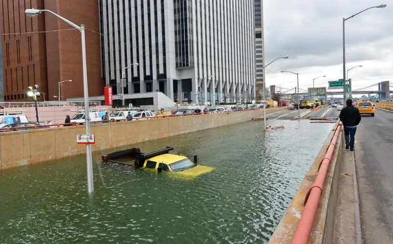
In 2011, Tropical Storm Irene made landfall on Coney Island and produced a storm surge of 4.36 feet and a storm tide of 9.5 feet at Battery Park. In 2012, Superstorm Sandy brought five feet of filthy, oil-laced surge in the lobby of South Street Seaport Museum.
The highest storm surge on record in New York City occurred during the September 3, 1821 hurricane, the only hurricane ever to make a direct hit on the city. The water rose 13 feet in just one hour at The Battery, and flooded lower Manhattan as far north as Canal Street, an area that now has the nation’s financial center.
The city is embarking on multibillion-dollar work to fight these climate hazards. The projects in The Battery are part of over $1.7 billion in Lower Manhattan Coastal Resiliency climate adaptation capital investments.
 These include the $350 million Brooklyn Bridge-Montgomery Coastal Resilience, which began construction in fall of 2022. Construction is also advancing on the $1.45 billion East Side Coastal Resiliency project, with the first two public areas opening in 2022 and 2023, and other coastal projects are in progress in all five boroughs.
For example, as part of the city’s citywide efforts to reduce coastal risk, the administration recently completed construction on the Old Howard Beach Street project, which will combat what would have been routine tidal flooding in 2050.
New York Mayor Eric Adams has called on the federal government to create a regular, recurring source of federal funding for coastal infrastructure that would enable New York City to complete resiliency projects. For every $1 invested in coastal infrastructure projects, $6 is saved in recovery costs, he said.
The Battery Coastal Resilience project is being led by the New York City Economic Development Corporation (NYCEDC), the New York City Department of Parks and Recreation (NYC Parks), and the Mayor’s Office of Climate & Environmental Justice (MOCEJ), Battery Coastal Resilience.
An interactive map by the National Oceanic and Atmospheric Administration (NOAA) shows “worst case scenario” sea level rise of 6.6 feet by 2100 – which the Intergovernmental Panel on Climate Change (IPCC) says “cannot be rules out.” You can see that map here.
Illustrations, from above: A truck submerged near the entrance to the Brooklyn Battery Tunnel in Lower Manhattan after Hurricane Sandy in 2011; a map of New York Citywide Coastal Resilience Projects (provided by MOCEJ); a map of Lower Manhattan Coastal Resiliency Projects (provided by NYCEDC).